Seven pyramids identified on the African island of Mauritius.
Text by Antoine Gigal - photos by Stéphane Mussard
In January 2008 Antoine Gigal and her team re-discovered the existence of 7 Pyramids on Mauritius Island (Plaine Magnien), she described the structures as true pyramids which have been forgotten for a long time by the world. In March 2008 the first article was published about them all around the world and the same month huge structures around the pyramids were also re-discovered. In June 2009 Gigal and her team discovered a lot of not yet identified pyramids in Sicily and also: important structures near by and around the Etna volcano. She discovered different shapes of pyramids. The Pyramids of Mauritius and Sicily are similar to those of Tenerife and others.
Seven pyramids have been identified on the African island of Mauritius. Remarkably, in construction, they are identical to the ones found on the island of Tenerife, an island on the opposite side of the continent. It underlines the likelihood that one civilisations to various islands off the coast of Africa and constructed these structures.
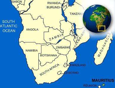
The island of Mauritius is part of the Mascarene Islands and is in the Indian Ocean, about 900 kilometres (560 miles) east of Madagascar. The island is 61 km long and 47 km wide, and sits just north of the Tropic of Capricorn. In origin, it is a volcanic island. The historical record shows that the island was known to Arab and Austronesian sailors as early as the 10th century; Portuguese sailors first visited in 1507. Mauritius was first plotted on a map in 1502, made by the Italian Alberto Cantino. The Arabs called the island Dina Harobi, while the planisphere identifies all three Mascarene islands (Reunion, Mauritius and Rodrigues) and calls them Dina Margabin, Dina Harobi and Dina Morare.
It is suspected that prior to the Arabs, Mauritius was known to certain people living on the African shores, as well as the famous Sea Peoples, a confederacy of seafaring raiders, which included the proto-Phoenicians. The Greek account of Periplus relates the story of Hanno (Hannan), the Carthaginian navigator, who lived in the 5th century BC, and who traversed the Straits of Gibraltar at the command of ships that would explore the African coastline along the Atlantic Ocean. Herodotus describes a Phoenician expedition leaving the Red Sea and traversing the “sea of the south”, and, following the orders of the Egyptian Pharaoh Necho II (610-595 BC), entered back into the Mediterranean Sea through the Straits of Gibraltar, which means they circumnavigated Africa.
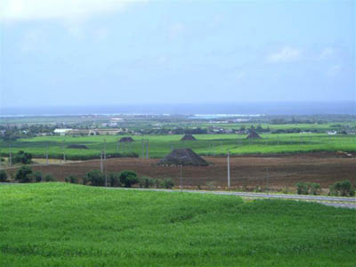
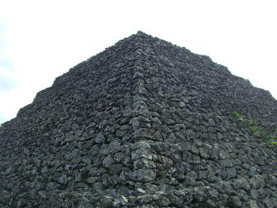
The seven small pyramids that have been identified are located on the south side of the island, in a plain known as Magnien, between the Indian Ocean and Creole Mountain and Lion Mountain, at 20°26’.8.15”S and 57° 39’2.60”E. Their foundation is rectangular and in height, they do not exceed twelve metres; they have between 6 and 11 terraces. In appearance, they are similar to the pyramids located on another volcanic island off the western – coast of Africa, Tenerife; similar structures also exist on the Mediterranean island of Sicily, which is also volcanic in origin. There are many parallels between the pyramids of Mauritius and Tenerife. On both island, the pyramids are part of a complex: a series of pyramids grouped together in one location. On both islands, the pyramids are made from lava stone and the construction does not use any mortar or other connecting agent. Some of the structures on Mauritius have been partially dismantled, with the stones reemployed nearby. In one coating of basalt rollers, there can be found limestone blocks underneath, no doubt of coral origin.
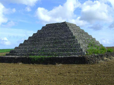
The Tenerife pyramids equally do not surpass 12 metres in height, and detailed photographs of the terracing makes it clear that one cannot distinguish whether one is observing a pyramid on Tenerife or Mauritius. In the case of “Mauritius Pyramid 1”, access to the upper platform is via a central staircase. This has been restored in a whiter stone, and is therefore more visible. Not all pyramids have such an access – again on par with their Tenerife cousins. It suggests that there is a commonality between the two islands that is beyond the coincidental.
Some of the Mauritius pyramids, with their platforms, could have been used for astronomical observations. This too would be on par with Tenerife, specifically at the Guimar complex. If this correlation were to apply to the Mauritius pyramids, these pyramids should be aligned to solar phenomena, and specifically the terraces associated with the pyramids should be aligned to the two solstices. Initial calculations suggest that this is indeed the case, though on-site verification needs to occur. Specifically Mauritius Pyramid 2 is likely to be aligned to the summer solstice (which in the Southern hemisphere occurs on December 21) and one should be able to observe a double sunset. The first sunset would occur behind the Creole Mountain, the second behind the neighbouring Lion Mountain. A double sunset behind a mountainous horizon is also a phenomenon observed at the Guimar complex in Tenerife.
Locally, as Stéphane Mussard experienced, the people claim these pyramids are merely stone piles, thrown together in efforts to clear the fields for growing sugar cane. Even the dismissals are therefore shared with those of Tenerife, where other complexes on the island (e.g. Icod de los Vinos) are equally labelled by locals as the result of farmers clearing their fields from unwanted stones. If this were true, the question is why some of the pyramids on Mauritius still have official panels, dating from the first half of the 20th century, which identifies the site as a protected site of historic interest? Remarkably, however, since, the site has lost its protected status, no doubt the consequence of a change in government (Mauritius was under British rule until 1968). It is clear that those dismissing these pyramids as “piles of stones” are afraid to see their agricultural lands repossessed, or having to conform to certain regulations that come with protected archaeological sites. It is never the less clear that with proper help, the government should be able to highlight the economic benefits of tourism to the local economy, which will hopefully result in scientific research carried out on the site.
The man responsible for the identification and promotion of the Guimar complex was ThorHeyerdahl, a pioneering sailor of Norwegian origin, who argued that our distant ancestors were able to navigate the oceans and organised various expeditions to prove his point. Heyerdahl found a pyramid in the Maldives, on Gan. This pyramid was aligned to the sun And measures 8.5 metres in height. It was baptised “Hawittas”. Heyerdahl argued that the Maldives were located on an Eastern maritime trading route that was used by various ancient civilisations, coming from the Middle East.
The ancient Egyptians used the Phoenician fleet to carry out expeditions, and it is known that the Phoenicians constructed astronomical temples that were perfectly aligned to the cardinal points and solar phenomena. With the discovery of identical pyramid complexes on Tenerife, Sicily and now Mauritius, it is clear that these are remnants of a seafaring culture, which has left traces on islands on various sides of the African continent.
All photographs are copyright Stéphane Mussard, and a copyright reference needs to be inserted as part of their reproduction.
Syndication: The above article can be reproduced, provided Antoine Gigal is identified as the author, and Histories & Mysteries is credited as the original source.
The Sicilian Pyramids
Of very High Antiquity
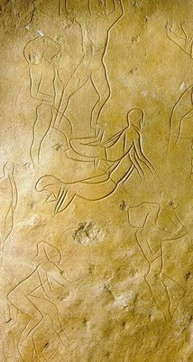
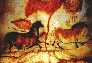
Human presence going back to as early as the end of the Pleistocene can be observed on the Mediterranean's biggest island (26,000 km²). Indeed, on this island located at the crossroad of many civilizations, drawings can be found in caves dating from 6,000 - 8,000 BC, in the Addaura caves near Palermo for example, or on the Aegadian islands. Many remains from the Upper Paleolithic can thus be found.
This island hosts numerous episodes of the Graeco-Roman Gods' mythological life; its patrimony is extremely rich, its vestiges very diverse. Only one of its heritages is particularly unrecognized: the pyramids... It is precisely those I went to seek during a detailed exploration with my team. So-called "primitive" agricultural communities have thus settled around the Aegean Sea around 6,000 BC. It is also said that this region's progress towards civilization was late, way behind Egypt and Mesopotamia. It might actually be much more nuanced than that. In The Odyssey, Homer refers to Sicily by calling it Sikania (in classical texts it is also called Sikelia) and mentions the Sicanian Mountains. This is why one of the three native people of Sicily was named the Sicani (or Sicanians) and would date from 3,000 BC to 1,600 BC, including the Early Sican period, more ancient, where various Mediterranean influences are mixed in the Neolithic population and would be localized more in the central and occidental part of the island. Much of our knowledge concerning the ancient Sicilians comes from the Greek literature, by famous writers such as Diodorus of Sicily, but little is said about the Sicani. Besides, the Greek historian Thucydides (460-394 BC), father of scientific history and political realism, considered the Sicani as a tribe coming from Iberia.
Text and photos by Antoine Gigal. www.gigalresearch.com - www.gizaforhumanity.org
Click here to buy the DVD of Antoine's talk at Megalithomania or download the MP3

